
A Systematic Methodology for Unmanned Excellence
Welcome to the Waynesboro Unmanned project intake portal, the primary gateway for Fair Lifts operations in East Georgia. We recognize that securing a quote for industrial-grade drone integration is a strategic decision that influences your seasonal yield, infrastructure longevity, and regulatory standing. Our team consists of more than just coordinators; we are technical consultants deeply embedded in the Waynesboro community, focused on translating your operational requirements into a high-precision, data-centric flight plan.
The pulse of Burke County is driven by an agricultural and industrial calendar that waits for no one. Whether you are managing vast cotton tracts near the Savannah River or overseeing large-scale timber operations along Highway 25, we understand that timing is your most valuable asset. Our "Analyze. Deploy. Validate." protocol ensures that every mission is handled with extreme efficiency and technical transparency, providing the high-resolution results required in the modern Coastal Plain economy.
The Waynesboro Operational Workflow
Phase 01: Localized Requirements Analysis
Every mission is predicated on a comprehensive discovery phase. For our agricultural partners, this involves a granular look at your acreage, crop varieties (such as peanuts, soybeans, or corn), and immediate biological threats. For our industrial and civil engineering clients, we assess terrain elevation, required spatial resolution, and specific data integration needs. In the Coastal Plain, we specifically calibrate our flight profiles to account for the region's unique sandy loam drainage patterns, high heat indices, and specific local airspace nuances.
Phase 02: High-Fidelity Tactical Execution
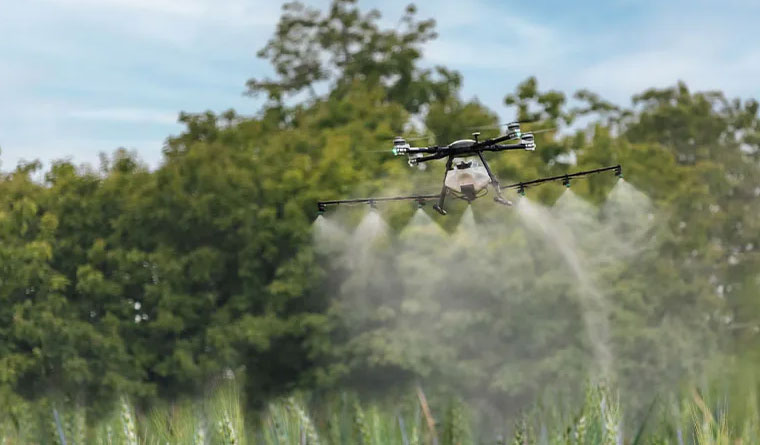
With a finalized flight plan in place, our Waynesboro-based crews move into action. Our local presence allows for a rapid deployment window that out-of-state contractors simply cannot provide. We utilize the industry’s most advanced platforms, from heavy-capacity XAG P150s for precision liquid application to WingtraOne VTOL systems for high-accuracy mapping. Our pilots adhere to a rigorous safety culture born from commercial aviation, ensuring that every flight hour is executed with centimeter-level accuracy while respecting the rural privacy and safety standards of Burke County.
Phase 03: Actionable Data Delivery
The mission is only complete once the data is in your hands and ready for implementation. For aerial application tasks, we provide comprehensive "As-Applied" documentation, serving as a verified record of coverage. For geospatial surveys, we deliver professional-grade orthomosaics, point clouds, and LiDAR datasets compatible with your existing GIS or CAD environments. We conclude every project with a technical review to confirm that the deliverables align with your projected return on investment.
Burke County Presence and Sustainable Partnership

Our investment in Waynesboro is a long-term commitment to the economic vitality of the "Bird Dog Capital of the World." We don't just fly; we build lasting relationships with the growers and industrial leaders of Burke County. To support this, we provide preferential scheduling and multi-season contract incentives for our local partners. By securing your service windows in advance, you ensure that your operations take priority during the intense Georgia summer when equipment availability is most constrained. We act as your dedicated technology wing, managing the hardware and the complex data so you can focus on your core business.
Frequently Asked Questions
Project Intake Form
Waynesboro Regional Office
Ready to Start Your Project?
Discuss your specific goals in Waynesboro with a regional expert. We provide rapid mobilization and precision scoping for every regional client.